Chesterfield Canal
A 46-mile canal running from the River Trent to Chesterfield, with a towpath popular for walking, cycling and wildlife spotting. It passes right through Retford.
Things to do
Walks, nature reserves and outdoor places you can reach from LNER stations. 26 ideas in total.
A 46-mile canal running from the River Trent to Chesterfield, with a towpath popular for walking, cycling and wildlife spotting. It passes right through Retford.
The 127-mile trans-Pennine canal passes through Shipley and Saltaire, and its towpath makes an easy, level walk between the two.
A 36-acre wood along the Eller Beck behind the castle, leased to the Woodland Trust, with a circular walk from the Old Sawmill entrance. Some paths are steep and there is no step-free access.
The coast-to-coast walking and cycling route between Southport and Hornsea passes through Selby, and a 15-mile spur heads north from the town to York.
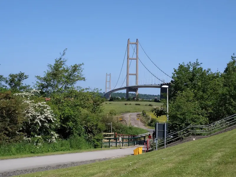
Opened in 1981, this Grade I listed suspension bridge spans about 1.4 miles of the Humber estuary. Its walkway is open to pedestrians and cyclists, and the surrounding estate has woodland paths and picnic spots.
A 79-mile National Trail from Hessle to Filey through the chalk hills of the Wolds, which passes by the eastern end of Brough.
York has the longest surviving town walls in England. The raised walkway forms a circular route around the centre and is free to walk throughout the year.
Designated in 1952, the national park contains the largest expanse of heather moorland in the UK, with walking and cycling routes of every length.
A half-cone hill near Great Ayton with a jagged summit and fine views across North Yorkshire and Cleveland; the countryside is open all day. The car park at Newton under Roseberry is run by the national park authority.
A 30-mile coastal walking route between Cockburnspath and Berwick-upon-Tweed, passing St Abbs, Coldingham Bay and Eyemouth along the way.
Dramatic cliffs with a busy seabird colony in summer, wildflower grassland, the Mire Loch and a nature centre; grey seals breed on the beaches in November and December. The reserve is open daily and entry is free.
A wild 650-acre royal park on the city's doorstep, dominated by Arthur's Seat, an extinct volcano rising to 251 metres with panoramic views.
The riverside walkway threads through the city past Dean Village, a former milling village below the Dean Bridge. The Water of Leith Conservation Trust posts current path closures on its website.
A long-distance trail of around 117 miles from Kincardine to Newburgh, split into day sections; North Queensferry, below the bridges, is on the route.
The 117-mile trail follows the Fife coast from Kincardine to Newburgh; the Fife Coast and Countryside Trust, which looks after it, is based in Dysart on Kirkcaldy's eastern edge and lists Kirkcaldy's beaches among its sites.
Shifting sand dunes, beaches, lochs and pine forest north of Leuchars, where seals haul out on the sandbanks and wading birds feed on the mudflats.
A Scottish Wildlife Trust reserve of red sandstone cliffs with sea caves, stacks, blowholes and arches, reached on foot from the promenade. Stick to the waymarked paths: the Trust warns of unstable edges and part of the path is closed (as of September 2026).
An enclosed estuary of the South Esk that attracts over 100,000 migratory birds in autumn and winter. The Scottish Wildlife Trust's visitor centre has telescopes and panoramic views across the reserve.
A Scottish Wildlife Trust reserve where ospreys return to a nest about 150 metres from the hides. Best for ospreys from April to August; red squirrels all year.
Towering Douglas firs line the paths to the Black Linn Falls, best seen from the 1757 folly of Ossian's Hall. In autumn you may see salmon leaping.
A wooded river gorge where the Battle of Killiecrankie was fought on 27 July 1689. Visit Soldier's Leap and look out for red squirrels; the visitor centre and site are free, with a charge for parking.
The dam and power station began generating in 1950 as part of the Tummel Valley scheme. Its famous fish ladder of 34 tiered pools helps salmon and sea trout upstream, and the visitor centre explains how.
Six waymarked trails start near the village, from the one-mile Red Squirrel Trail to the 10-mile Glen Tilt Trail. During stag stalking (1 August to 20 October) keep to main paths.
Ten square kilometres of River Spey floodplain between Kingussie and Kincraig, home to breeding curlews, lapwings, redshanks and snipe. There are no toilets on site.
Ride the UK's highest funicular railway, or try the mountain carts, bike park and play areas in summer and snowsports in winter.
An estate of ancient Caledonian pine forest in the heart of the Cairngorms, with walks to Loch an Eilein, a farm shop, a café and outdoor activities.
Nothing matches that region yet. Try another region or type.
Distances are approximate and measured from the station. Opening times, prices and booking rules change, so check the official website before you travel.
Check live times and fares with LNER, or compare prices on Trip.com. Book early for the best chance of a cheaper Advance fare.